Home
Contact
About Us
My Account
+61 404 131 697
sclark@theoldmapshop.com
My Account
Welcome to The Old Map Shop!
Login
Create Account
0
The Old Map Shop
Maps
Africa
America
Canada
Mexico
United States
South America
Asia
Afghanistan
China
India
Indonesia
Japan
Korea
Malaysia
Pakistan
Philippines
Sri Lanka - Ceylon
Thailand
Australia & Oceania
Australia
Canberra
Hobart
Melbourne
Sydney
New Zealand
Oceania
Europe
Austria
Belgium
Denmark
France
Germany
Greece
Ireland
Italy
Luxembourg
Netherlands
Poland
Portugal
Russia
Spain
Sweden
Switzerland
Middle East
Arabia
Iran
Israel
Palestine
Turkey
Great Britain
England
Ireland
Scotland
Wales
Celestial
Pictorial Maps
Archived - Sold
Prints
Botanical
Sowerby - Wildflowers
Lindman - Flowers
Lowe - Ferns
Eggs & Nests
Fairies
Cicely Mary Barker
Ida Rentoul Outhwaite
Ferns
Shells
Country Life
Portraits
Currency
AUD - (Australian $)
CAD - (Canadian $)
EUR - (Europe € )
GBP - (British £ )
NZD - (New Zealand $)
USD - (United States $)
0
Shopping Cart
Your cart is currently empty.
Continue Shopping
My Account
Welcome to The Old Map Shop!
Login
Create Account
Home
England Maps
England Maps - Antique England Maps & Pictorial Maps from the 16th - 20th Century.
England Maps
Useful Links
Antique Maps
Africa
Hit enter to expand submenu
America
Canada
Mexico
South America
United States
Hit enter to expand submenu
Asia
Afghanistan
China
India
Indonesia
Japan
Korea
Malaysia
Pakistan
Philippines
Sri Lanka - Ceylon
Thailand
Hit enter to expand submenu
Australia & Oceania
Australia
Canberra
Hobart
Melbourne
Sydney
New Zealand
Oceania
Hit enter to expand submenu
Europe
Austria
Belgium
Denmark
France
Germany
Greece
Ireland
Italy
Luxembourg
Netherlands
Poland
Portugal
Russia
Spain
Sweden
Switzerland
Hit enter to expand submenu
Great Britain
England
Ireland
Scotland
Wales
Hit enter to expand submenu
Middle East
Arabia
Iran
Israel
Palestine
Turkey
Celestial
Pictorial Maps
Hit enter to expand submenu
Antique Prints
Hit enter to expand submenu
Botanical
Sowerby - Wildflowers
Lindman - Flowers
Lowe - Ferns
Eggs & Nests
Hit enter to expand submenu
Fairies
Cicely Mary Barker
Ida Rentoul Outhwaite
Ferns
Shells
Hit enter to expand submenu
Country Life
Portraits
Archived
Pictorial Maps
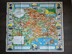
Dale, O. J. 1934, Pictorial map of the city and surroundings of Melbourne
$900.00
1950 Marche e San Marino, Italy Pictorial Map De Agostini
$48.00
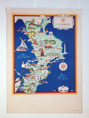
1950 Calabria, Italy Pictorial Map De Agostini
$48.00
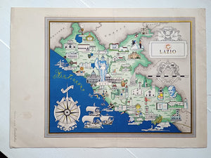
1951 Lazio Italy Pictorial Map De Agostini
$42.00
Sort by:
Featured
Best Selling
Alphabetically, A-Z
Alphabetically, Z-A
Price, low to high
Price, high to low
Date, new to old
Date, old to new
Filter
Quick View
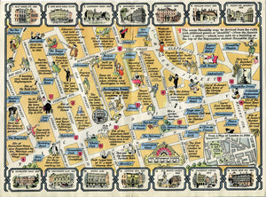
1937 Coronation Route King George 6th London Pictorial Map by Claude Atkinson
$265.00
Quick View
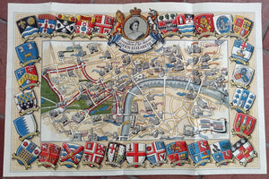
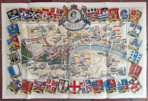
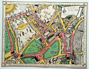
1953 Historic Queen Elizabeth II Royal Coronation Route London Pictorial Map
$300.00
Quick View
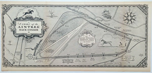
1930 A Chart of Aintree Race Course by George Annand. Pictorial Racecourse Map
$155.00
Quick View
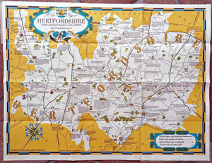
1950 Wayfarer Pictorial Map Hertfordshire, Herts by Leo Vernon
$160.00
Quick View
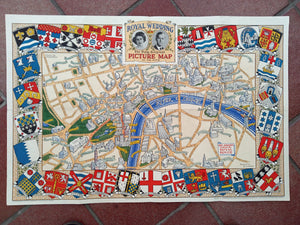
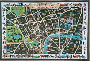
Royal Wedding 1947 Daily Telegraph Picture Map of London, Pictorial Route
$450.00
Sold Out
Quick View
1953 Historic Queen Elizabeth II Royal Coronation Route Pictorial Map London
$0.00
Sold Out
Quick View
1937 London Pictorial Map by Claude Atkinson, Coronation Route King George 6th
$0.00
Quick View
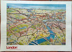
Very Rare 2003 London Olympic Venues, Pictorial Map, Poster, Underground Railway Stations, Transport
$3,650.00
Sold Out
Quick View
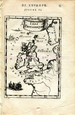
1683 Manesson Mallet "Isles Britanniques" British Isles, Great Britain, England, Ireland, Scotland Antique Map, Print, Engraving
$0.00
Quick View
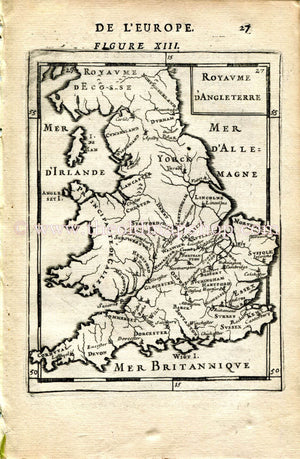
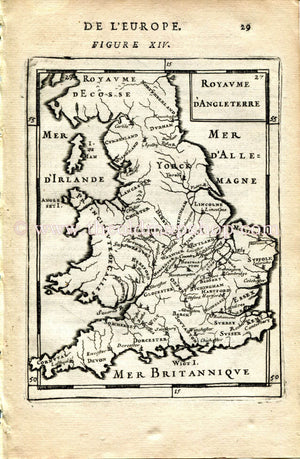
1683 Manesson Mallet Map "Royaume D'Angleterre" England, Wales, Scotland Antique Print Engraving
$50.00
Quick View
1683 Manesson Mallet "Royaume D'Angleterre" England, Scotland, Wales Antique Map Print Engraving
$50.00
Sold Out
Quick View
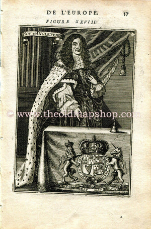
1683 Manesson Mallet "Roy D'Angleterre" King Charles II of England, Antique Print, Engraving
$0.00
Quick View
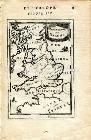
1683 Manesson Mallet "Heptarchie des Saxons" Saxon Britain, England, Ireland, Wales, Scotland Antique Map Print Engraving
$65.00
Sold Out
Quick View
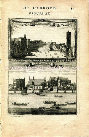
1683 Manesson Mallet "Westminster-Haal" Hall & Abbey, River Thames, Boats, London, England, Antique Print, Engraving
$0.00
Quick View
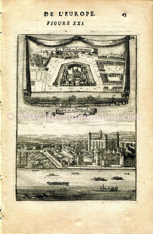
1683 Manesson Mallet "La Tour de Londres; Profil de la Tour de Londres" Tower of London, River Thames, England, Antique Print, Engraving
$45.00
Sold Out
Quick View
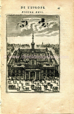
1683 Manesson Mallet "Bourse de Londres" London Stock Exchange, England, Antique Print, Engraving
$0.00
Sold Out
Quick View
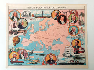
1948 Europe "Essor Scientifique de L'Europe" Pictorial Map, Print by Joseph Porphyre Pinchon. Italy, Greece, France, Germany, Spain, England
$0.00
Quick View
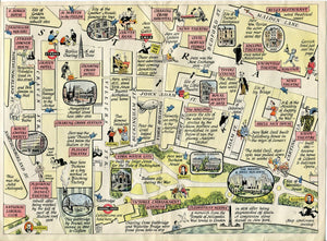
1946 A Map of Piccadilly, London. A Pictorial Map by J. P. Sayer
$100.00
Quick View
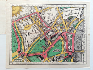
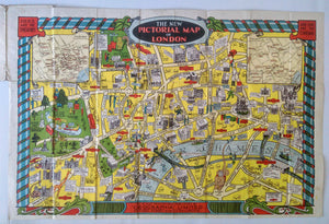
The New Pictorial map of London by Geographia ltd c.1934. Map Poster
$545.00
Quick View
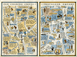
1947 A Map of Charing Cross & Trafalgar Square, London. A Pictorial Map by J. P. Sayer
$100.00
Quick View
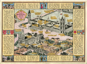
1947 A Prospect of Westminster from The South-West, London. A Pictorial Map by J. P. Sayer
$100.00
Quick View
1947 A Map of the Strand, Trafalgar Square to Aldwych, London. A Pictorial Map by J. P. Sayer
$100.00
Quick View
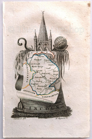
1823 Scarce A. M. Perrot Antique County Map, Lincoln, Lincolnshire, England
$55.00
Quick View
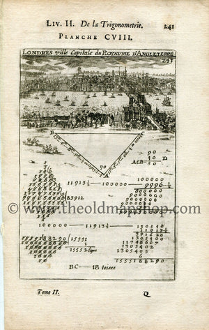
Rare 1702 Manesson Mallet Antique Map, Print, Engraving - Perspective, Bird's-eye View, London, England- No.108
$120.00
Quick View
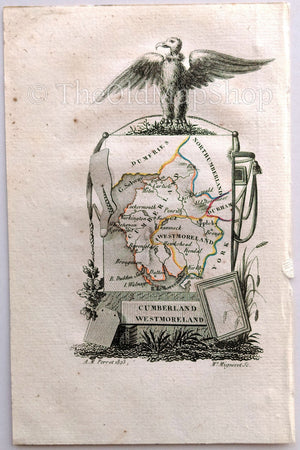
1823 Scarce A. M. Perrot Antique County Map, Cumberland, Westmoreland, England
$55.00
Quick View
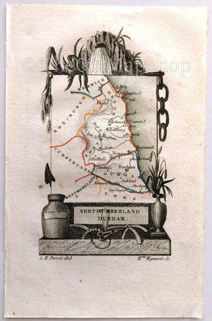
1823 Scarce A. M. Perrot Antique County Map, Northumberland, Durham, England
$55.00
Quick View
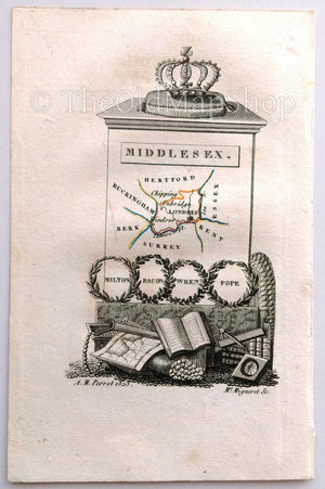
1823 Scarce A. M. Perrot Antique County Map, Middlesex, London, England
$55.00
Quick View
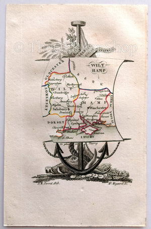
1823 Scarce A. M. Perrot Antique County Map, Wiltshire, Hampshire, England
$55.00
Quick View
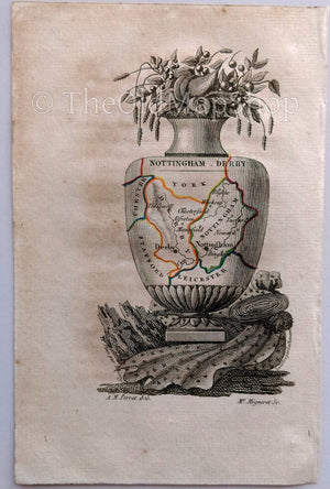
1823 Scarce A. M. Perrot Antique County Map, Nottinghamshire, Derbyshire, Nottingham, Derby, England
$55.00
Quick View
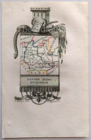
1823 Scarce A. M. Perrot Antique County Map, Oxfordshire, Berkshire, Buckinghamshire, Oxford, Buckingham, England
$55.00
Quick View
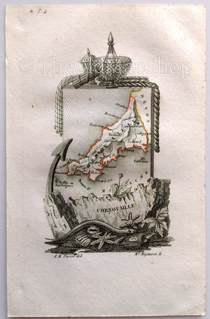
1823 Scarce A. M. Perrot Antique County Map, Cornwall, England
$55.00
Quick View
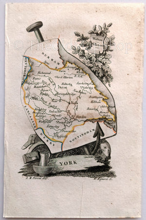
1823 Scarce A. M. Perrot Antique County Map, York, Yorkshire, England
$55.00
Sold Out
Quick View
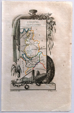
1823 Scarce A. M. Perrot Antique County Map, Cheshire, Lancashire, England
$55.00
Sold Out
Quick View
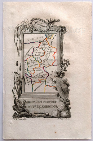
1823 Scarce A. M. Perrot Antique County Map, Hertfordshire, Bedfordshire, Huntingdon, Cambridgeshire, England
$55.00
Quick View
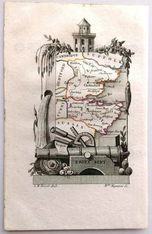
1823 Scarce A. M. Perrot Antique County Map, Essex, Kent, England
$55.00
Quick View
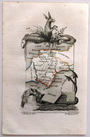
1823 Scarce A. M. Perrot Antique County Map, Devonshire, Devon, England
$55.00
Sold Out
Quick View
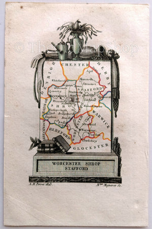
1823 Scarce A. M. Perrot Antique County Map, Worcestershire, Shropshire, Staffordshire, Worcester, Stafford, England
$55.00
Quick View
c.1950 The Daily Telegraph Picture Map of London by Vale Studios Ltd. Publisher - Geographia Ltd. Pictorial Map poster.
$210.00
Quick View
Great Britain, England, Ireland, Antique Map c.1920 - A scarce advertising card for La Belle Jardiniere, shopping center, Paris France
$60.00
Quick View
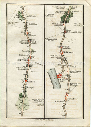
1790 John Cary Antique Road Map 51/52 Bexleyheath, Crayford, Dartford, Stone, Northfleet, Gravesend, Chalk, Shorne
$85.00
Quick View
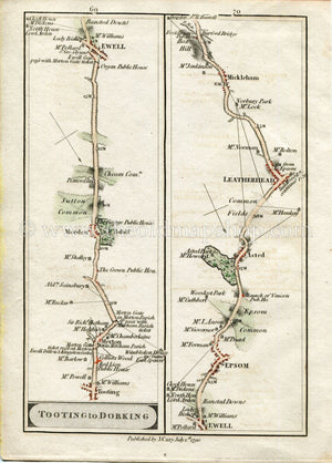
1790 John Cary Antique Road Map 69/70 Tooting, Merton, Morden, Ewell, Epsom, Ashtead, Leatherhead, Mickleham
$85.00
Quick View
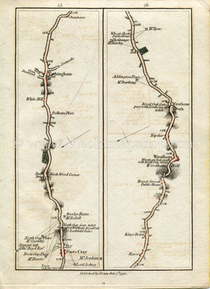
1790 John Cary Antique Road Map 55/56 Foots Cray, Farningham, Kingsdown, Wrotham, Wrotham Hill, Wrotham Heath, London
$85.00
Quick View
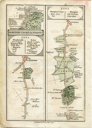
1790 John Cary Antique Road Map 77/78 Guildford, Hampton Court, Kenton Park, Sunbury Common, Staines
$85.00
Sold Out
Quick View
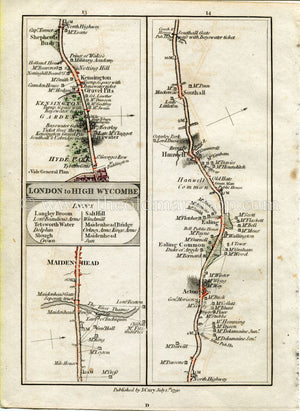
1790 John Cary Antique Road Map 13/14 Maidenhead, London, Kensington, Notting Hill, Shepherd's Bush, Acton, Ealing, Hanwell, Southall
$85.00
Quick View
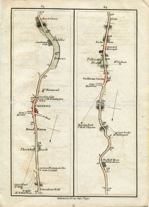
1790 John Cary Antique Road Map 63/64 Streatham Wells, Broad Green, Croydon, Riddlesdown, Godstone Green, Tilburstow Heath
$85.00
Quick View
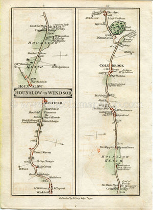
1790 John Cary Antique Road Map 9/10 Winkfield, Newell Green, Binfield, Hounslow, Cranford Bridge, Sipson Green, Longford, Colnbrook Datchet
$85.00
Quick View
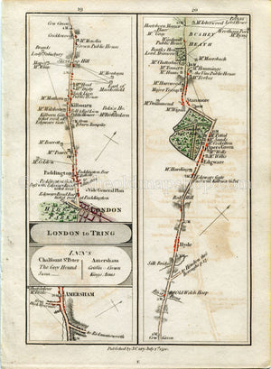
1790 John Cary Antique Road Map 19/20 Amersham, London, Paddington, Kilburn, Cricklewood, The Hyde, Edgeware, Stanmore, Bushey Heath
$85.00
Sold Out
Quick View
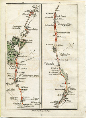
1790 John Cary Antique Road Map 21/22 Bushey Heath, Watford, Hunton Bridge, Kings Langley, Bourne End, Berkhamsted, Northchurch
$0.00
Previous
1
2
Next